
Maritime archaeology on the warship Hazardous in Bracklesham Bay
Archaeology
In 1966, a gun was raised from the vicinity of the wreck but it was not until 1977 that local divers discovered two guns protruding from the seabed and identified it as a wreck site.
During the 1980's, artefacts and concretions were raised and examined proving to be late 17/18th century. Cannon were surveyed in situ and a full pre-disturbance plan of the wreck site was completed. It was established from the evidence collected and from historical records that the wreck was that of the warship Hazardous.
In 1986 the site was designated a protected wreck site.
Intrusive excavation was carried out in 1988 and 1989. A trench forward on the port side established the extent of buried remains and evidence of the extent of the ship surviving was gained and relatively undisturbed stratigraphy was encountered along with features and artefacts in secure contexts.
A detailed examination of a gun and carriage exposed during excavation was carried out with the hope of recovery and conservation. Two cannon were raised for identification and conservation but the process used was unsuccessful.
Examination of construction, showed distinctively French characteristics. Her frames, for example, are set in longitudinally bolted pairs while frames in the bow are set at increasing angles. Such cant frames were not introduced into English warships until around 1715. In addition, the site was found to be littered with lead strips, also found driven between planking as caulking. Other uses for lead alloy on the ships were found to include it being placed between components of her laminated bow structure (Fenwick and Gale 1998).
The wreck comprises of principally the lower hull, which lays in fine sand and silt to the north and on fossil bed formations to the south, east and west, in a general sea bed depth of 7 metres.
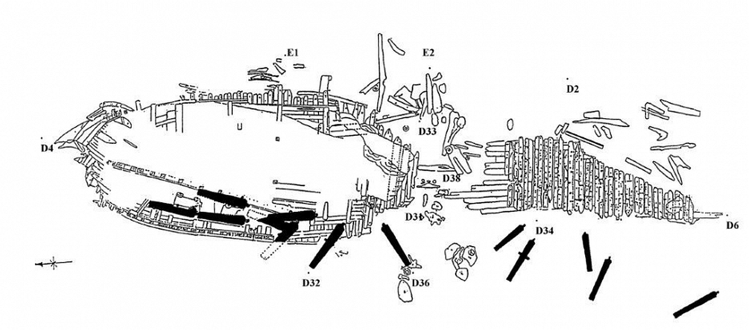
The hull is in two parts; the larger part, thought to be the bow lying to the north and the other, of lighter construction thought to be the stern, lying to the south. These remains extend some 42 metres and 13 metres respectively along a north-south axis. Most of the bow remains buried. There appears to have been a transverse breach of the hull at the amidships section and forward of this, the bow section has become buried within the seabed. The port side appears to have survived to slightly above gun deck level and the starboard side only slightly above the keel. A storm in 1990, caused the stern section of the hull to disappear, demonstrating the dynamic nature of the site.
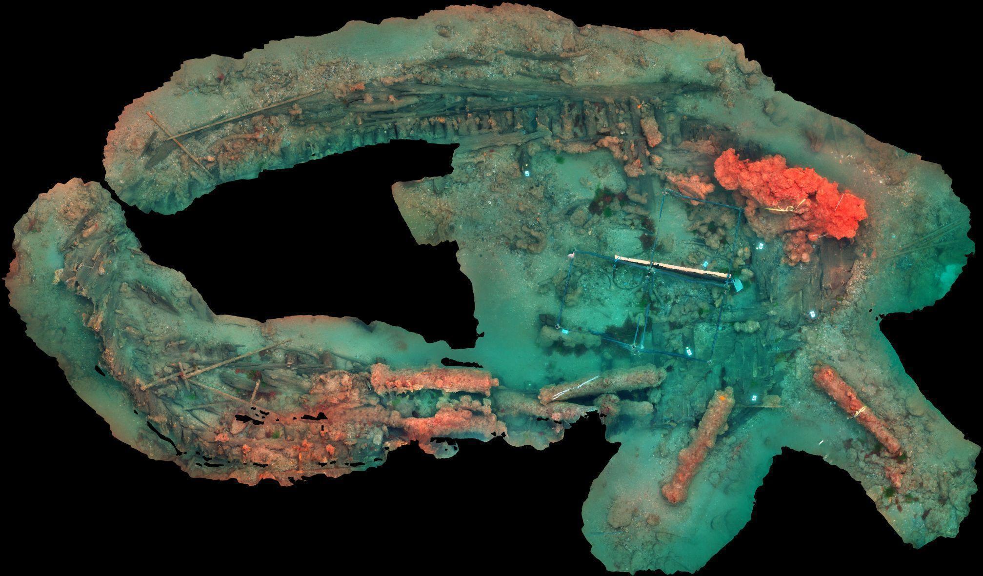
Photogrammetry image of the site by Rodrigo Ortiz.
During the early 1990s, changes in erosion patterns were observed, timbers, concretions and artefacts were being freshly exposed. Due to the excellent state of preservation of the exposed timbers, it was assumed that the wreck had remained relatively stable from the time of wrecking.
Remote sensing, undertaken in 2014 by Wessex Archaeology for Historic England, revealed two seabed anomalies outside the restricted area. One, laying 10m to the south-west, has been identified as nine cannon. Further archaeological material, comprising bar shot and a lead scupper, was discovered in the same area with more material believed to lay beyond this. This material is most likely associated with Hazardous having become dislocated during the wrecking process.
The other anomaly, laying 25m to the east of the restricted area, has yet to be fully ground proved but is believed to be also ships timbers and other material associated with Hazardous.
The protected area was extended in 1988 and 2017 to include the additional findings.
The principal threat to the archaeological remains is the continued reduction of sand cover over the wreck. Previous reports compiled by the group have highlighted the destruction of extensive areas of the surviving ship structure as the movement of protective sand deposits have uncovered it. Illegal fishing and trawling over the site has also been reported to Historic England.
Hazardous Project Group
The Hazardous Project Group consists of a small number of avocational divers assisted by an archaeological advisor. A project group has been active since formed in 1984 by club divers from Sub-Aqua Association (SAA) 308.
While diving into 300 hundred years of history to reveal the past is probably the more 'romantic' notion of the group's activity, there is also a considerable amount of support work that has to be undertaken; equipment has to be maintained, artefacts have to be processed and regulatory obligations fulfilled.
All these activities depend on getting people together when they have other commitments elsewhere.
The number of dive visits per year varies, on average about 10. At times the group does get the support of occasional divers, but even then, getting out to the site and being able to dive it can be challenging. Each visit depends on diver availability, weather and sea state and sometimes even the ability to launch.
Routine dive activity consists primarily of observing and recording the ever changing state of the site and to take any action required to preserve archaeological integrity. The wreck sits in an area with a longshore drift that moves sediment along the shoreline. The effect, aside from deciding water clarity, is that sometimes the site gets buried and on other occasions scoured and new sections exposed. Winter storms too can have a very unpredictable and detrimental effect.
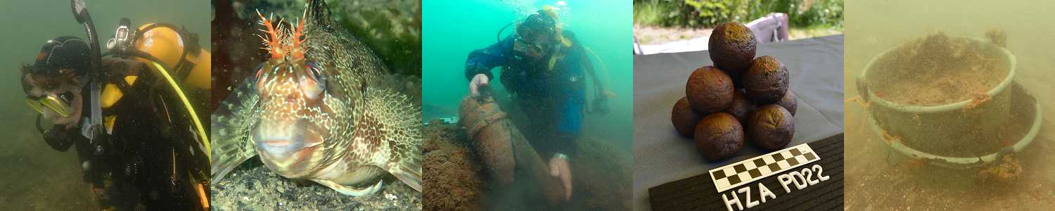
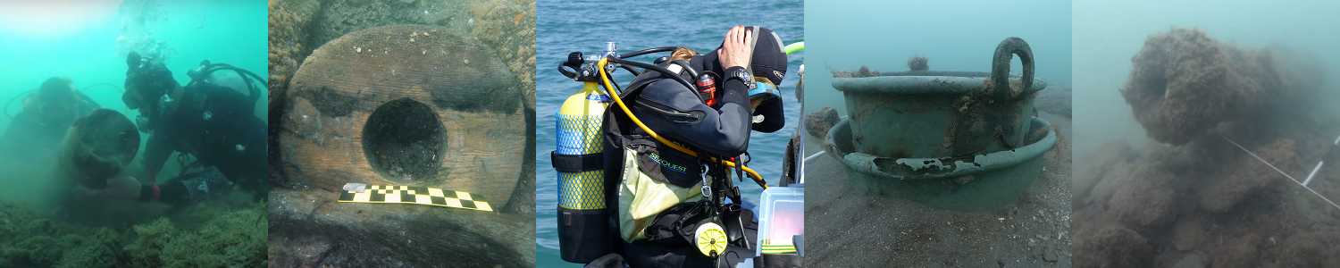
Preserving archaeological integrity includes the collection of exposed artefacts to ensure they are not lost to erosion. However logging and lifting is just the start of a much longer process of identification, cataloguing, reporting, stabilizing, preserving and eventually setting them for public display.
Previously the group maintained an artefact preservation and storage facility at Earnley Gardens near Bracklesham Bay. Unfortunately the gardens have closed and the group obliged to vacate the facilities they had. They are currently in negotiations for alternative arrangements.
Excavation of the site has been attempted several times over the years but the inconsistencies of tide and weather has often meant a planned excavation being cancelled or only partly achieved. Excavation is an intensive operation requiring divers, equipment and boats and the funding to support it, provided largely by Historic England. Specific permission has to be obtained for excavation which is not open-ended so each attempt requires significant organisation which unfortunately still depends on the vagaries of weather.
For many years members worked without official funding, contributing their own time and money to keep the project going. More recently there has been funding from English Heritage, the Lottery Fund and other bodies, which has allowed the purchase of filming and computer equipment to better record group activity. It is also intended to fund further excavation.
The site has an established 'Diver Trail' scheme run and organised by the Hazardous Project Group. (While currently not open for use, it is planned to resurrect it)
One of the prime functions of the group over many years has been publicisation of the work undertaken by the group and the history of the ship. There have been a number of magazine and newspaper articles and a small booklet about Hazardous was printed. The ship has been featured on radio and in the television programmes Wreck Detectives and Digging for Britain. There have been presentations to schools, conferences and interested organisations and to a number of visiting diver groups that have accessed the Diver Trail.
Below are links to some of the more recent publications about Hazardous.
Below are links to some of the more recent publications about Hazardous.
Each year the licensee submits a report showing in some detail the activity, achievements and frustrations involved. Reports are in pdf format and can be seen on-line, downloaded or printed.
Artefacts
Finds recovered from the site include stoneware, pewter, items of apparel and other personal possessions, numerous navigational dividers, cannon balls, musket and pistol shot. Many more artefacts have yet to be recovered as excavation progresses.
Artefacts were displayed at Earnley Gardens which has sadly now closed. The group is currently negotiating alternative arrangements for the display of artefacts.
The Maritime Archaeology Trust have undertaken an Archive Assessment and Enhancement funded by English Heritage.
Some of the findings of this project, including reports, a database and images, can be seen on the Archaeological Data Service website.
Protected Site Details
Designation History: Designation Order: (No 1), No 1441, 1986 Made: 21st August 1986 Laid before Parliament: 1st September 1986 Coming into force: 22nd September 1986 Protected area: 50m within 50 45.10 N 000 51.47 W.
Designation Order: No 287, 1988 Made: 19th February 1988 Laid before Parliament: 26th February 1988 Coming into force: 18th March 1988 Protected area 100m within 50 45.10 N 000 51.47 W.
Designation Order: No 773, 2017 Made: 18th July 2017 Laid before Parliament: 19th July 2017 Coming into force: 18th August 2017 Protected area 135m within 50 45.10 N 000 51.47 W.
No part of the restricted area lies above the high-water mark of ordinary spring tides.
If you have any questions regarding Hazardous, please contact the licensee of the wreck site :
Iain Grant
Meadowcot
Barn Road
East Wittering
PO20 8NL
Tel: 01243671116
By email: Licensee